
This article is in continuation of a previous one and a part of my Ladakh and Zanskar Valley travelogue. We spent an entire day sightseeing in Sham Valley and this page provides a detailed log of the same. To read the previous parts of the journey, please click on the links below.
Journey so Far
- Day 1 & 2 – Delhi to Jispa
- Day 3: Jispa to Tso Kar. Night Stay at Tso Kar
- Day 4: Tso Kar to Leh
- Day 5 & 6: Leh – Local Sightseeing, Friends, Hospital, and Rest
Sham Valley is one of the most visited tourist areas of Ladakh. I think it is largely because of its easy accessibility from Leh. The valley is located along the Srinagar Leh Highway and can be easily covered in a single day from Leh. If you were short on time, you can in fact visit Sham Valley while traveling between Leh and Kargil, as we did.
But not many people actually drive into the Valley. They stay along the Srinagar Leh Highway and only cover spots like Magnetic Hill, Indus Zanskar Confluence, and Gurudwara Patthar Sahib. Sham Valley is much more than that and there are several other places to see here. For a complete list, please take a look at How to Plan a Trip to Sham Valley.
Quick Navigation
Sham Valley Sightseeing Plan
Day 7 was our day of ‘detours’, the day when we planned to explore all kinds of ‘motorable treks’ if that makes any sense. By detours, we mean mostly exploring and going to ‘ends-of-roads’. All the detours were planned off the Leh – Srinagar highway.
It was going to be a long day, but after two days of complete rest, we were upbeat and looking forward to some off-roading. The idea was to leave the highway and go off the road. We wanted to visit the places that not many people go to and we were not even sure how far the road was going to take us.
Day 7 – Sightseeing in Sham Valley & Srinagar Leh Highway
We left our hotel at 6:15 am the next morning. In half an hour, after a quick stop at the gas station, we had reached the straight road after Leh airport. The morning light made the landscape look heavenly, and hence our progress was slow.
All flights landing in and flying out of Leh are scheduled for early in the morning because that is when the weather is most stable. We saw several flights landing, and enjoyed the sight of a lonely plane flying against the barren and majestic mountains.
We did not stop at the Magnetic Hill to experiment this time, having already decided last year that it was an optical illusion. Soon, we reached Nimmu, and after photographing the confluence of the Zanskar and Indus rivers, we continued towards our first planned detour of the day – to Chilling and the end of the road beyond it.
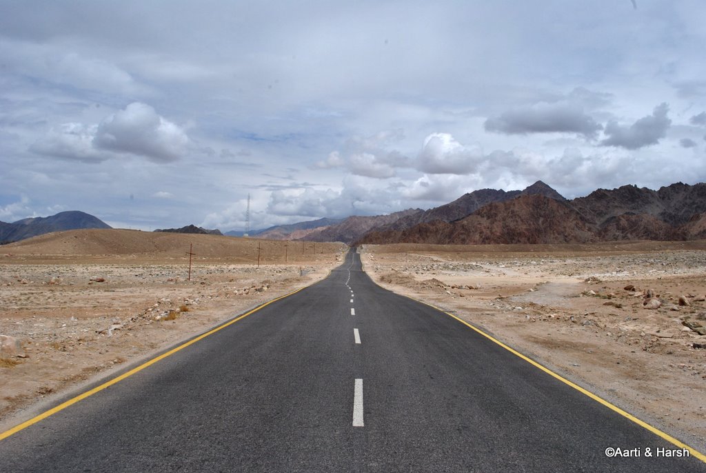
A wonderfully tarred road before Magnetic hill

The famous Magentic hill provides the perfect setting for a lot of ads.

The confluence of Indus & Zanskar at Nimmu

Leh to Chilling
The road to Chilling runs along the Zanskar River, in a very narrow and dark valley. It is actually more like a gorge than a valley, with cliffs jutting into the river. The mountains seem to be made of hard rock and give a very rugged appearance.
The rock, they say, is also quite difficult to cut through. It is no wonder that a land-trek route does not exist on this stretch; and people have to walk on the frozen Zanskar River (the famous Chadar trek) in the winters to reach Leh from Padum.
The mountains also get a purplish tinge here and remind somewhat of the valley after Tanglang La. The ferocious Zanskar rives enthrall throughout, and one can just stare at the river for hours admiring its beauty. That is one river with a personality of its own!
Also Read: How to Plan a Trip to Zanskar Valley
Chilling is 28 km from the cut from the highway. The village is not really on the road but a bit higher. There are some home-stays available at the village and some dhabas as well. However, when we reached Chilling, it was still too early for the dhabas to have opened.
Beyond Chilling, we crossed a few groups of foreign trekkers on the way, probably doing the Markha Valley trek. The poor souls were trekking on what is now a motor-able road. It must surely be not fun anymore!
The rugged terrain on the Nimmu – Chilling road

The chilling village, a splash of green in an otherwise brown surrounding

Chilling Village
We continued on the now not-so-good road and crossed a BRO camp. Finally, after 10 km or so, we reached a point where the road was blocked due to construction work. We could not go further. On talking to the BRO officer overseeing the work, we got to know that the road had only been blasted another 2 km from that point.
On the way back, we saw the trail marking the beginning of the well known Markha valley trek on the other side of the river. The most surprising part was that the track seemed to be used by four-wheelers, although there was no bridge over the Zanskar for four-wheelers to cross! The trekkers, whom we had crossed earlier, were using a traditional pulley arrangement to cross the river one at a time. It looked pretty scary!
Then we got down to some calculations. The distance from Nimmu to Padum is 150 km, out of which approximately 45 km of road was ready from Nimmu. 45 km in 7 years, that’s about 7 km a year! It really must be a hard task for the BRO guys.
We did not know the status of the road from the Padum side and had to wait for the Zanskar leg of our trip to find out. For the time being, it was 105 km to go.
We then drove back all the way to Chilling, the weather being very cloudy and adding to the darkness of the already dark Zanskar valley. After a tasty breakfast of pancakes at some dhabas on the main highway at Nimmu, we moved on, our next detour being the Sham valley.
Heading back towards the highway

Basgo Palace and Monastery
We drove by the famous Basgo Palace/ Monastery and contemplated visiting it. But we were a bit short on time and decided to give it a miss. Immediately after the Palace, the road starts ascending, and some good shots of the Palace can be taken from the switchbacks. At the end of the ascent, the lovely Basgo plains welcomed us, and we reveled for a bit at the sight of the long, straight road in front of us.
The ruins of the Basgo Palace

The flat, huge, Basgo plains! Not as huge as More Plains of course.
Likir Village and Monastery
We had to look up the Leomann map to figure out the cut for the Sham valley. The road was tarred but narrow. Three Chortens, blue, white, and yellow, welcomed us to the valley. We came to a point on the road from where one track went into Sham valley, and the other towards Likir.
We took the latter first since we wanted to see the Likir Monastery and the giant Buddha, albeit only from a distance. The road climbs considerably as one goes towards Likir, and soon the Monastery, with the huge golden Buddha next to it, comes into view.
A few locals were taking a lift in our car, so we went all the way up till the parking of the Monastery and then came back.
Likir Monastery and the huge Buddha idol on the right of it.

Phobe La Pass
Subsequently, we took the cut into Sham valley where the road winds in a broad, very barren, and totally brown landscape. Green patches can be seen every 7 or 8 km, which are usually small villages or hamlets of a couple of households.
The mountains have a slight pinkish-purplish tinge, which gives the whole place a surreal effect, and it sometimes feels like you’re driving through a painting.
We also spotted trekkers every few kilometers and were not surprised as we knew that the Sham valley trek is very popular. Especially because it is relatively easy, is close to Leh, and does not require permits of any kind. Every village we crossed had umpteen camping spots to cater to the abundant trekkers in the valley.
Also Read: How to Handle Acute Mountain Sickness in Ladakh
The first pass we crossed in the Sham valley was Phobe La, which, at 3600 m, was a gentle climb. This pass is also spelled as Pobe La or Phoebe La. The track was pretty much tarred all the way to the top.
The descent to the village of Sumdo begins immediately after the pass. I wonder why so many villages in Ladakh are called Sumdo. They do have creativity issues on that front for sure!
The unceremonious Phobe La top

Chagatse La Pass
After Sumdo, we begin climbing the next pass on the route, Chagatse La (also spelled as Charatse La) at 4000 meters. The ascent is pretty steep with a few difficult switchbacks, but thankfully the track is tarred all the way. Charatse La was completely barren!
Also Read: How to Calculate the Total Cost of Ladakh Trip
No green could be seen anywhere, except in the valley below, where we could spot a lush green village, Yangthang, nicely located in the middle of a bowl-type valley. As a friend says, it would make the perfect setting for the world’s most picturesque golf course. Sadly, the people of Yangthang somehow prioritize farming over golfing, don’t know why?!
A flag at Chagatse La.

The beautifully tarred road till Charatse

Tsermangchen La / Settmanchan La
Our progress was slow after Chagatse La, as the track lost it’s tar and was replaced with a sandy descending jeepable track. Immediately after descending to Yangthang, the climb to the next pass began.
The climb to Tsermangchen La (also spelled as Settmanchan La) at 3850 m was even more difficult than the last one, with the track getting very sandy at places. Still, we did not feel the need to engage 4WD yet.
As I was taking one turn, the unthinkable happened. Kiyang lost power and stalled! It sputtered wildly, with thick black smoke billowing out of the exhaust. It shivered as one shivers upon taking a plunge in a swimming pool on a cold October evening, and stopped dead in its tracks!
My heart sank. I had been extra careful with the maintenance schedule of the vehicle, and it was equipped with a recent oil change, clean filters, and even a chemical cleaning of the catalytic converter had been done before the trip. This sputtering was something new to me, it had never happened before.
Kiyang had easily crossed difficult passes such as Charchagan La and Marsimik La last year and had never experienced any issues. So there had to be something very wrong with it to have bowed to Settmanchan La which is only at 3850 m!
However, before I could fret further, Kiyang immediately regained its composure. Everything went back to normal as if nothing had ever happened. The remaining climb to Settmanchan La was uneventful. But that feeling of unease that something was wrong with the car stayed with us.
Also Read: How to Prepare your Car for Leh Ladakh
Hemis Shukpachan
The view of the next village, Hemis Shukpachan, from the pass was absolutely amazing. In contrast to the light sandy brown of the mountains, the huge, lush green patch in the middle of the valley below seemed as if a drop of green paint had accidentally dropped from God’s brush in his otherwise brown painting.
As we approached the village, it became apparent that Hemis Shukpachan was definitely the biggest of all villages we’d seen in the Sham valley yet. Chancing upon a villager, we asked if there was a road linking the village directly to the highway. We were jubilant when he said yes because we were in no mood to go all the way back to almost Nimmu to join the highway.
A view of Hemis Shukpachan village from Settmanchan La / Tsermangchen La

Approaching Hemis Shukpachan

Pretty houses dot this village

The road going back to the highway is beautiful too.

A few words about Hemis Shukpachan. There was something about this quaint village that was really attractive which I’m unable to express. For those looking for a good homestay near Leh, it provides an ideal setting. Traditional Ladakhi houses, small nallahs everywhere, pretty flowers, and cute kids can be found in all villages in this region, and Hemis Shukpachan was no different.
However, it had that extra something that I’m unable to put my finger on. The road that leads to the highway goes through the village and is an absolute treat to drive on. It is lined with trees on both sides, and running along a river. It is a beautiful village that you can spend a couple of days in and use it as a base to explore and for sightseeing in Sham Valley.
Also Read: What Clothes Should you Pack for Ladakh
Back on the Highway
We did not have time to explore the village that day. but decided that someday we would like to spend a day here. For now, we had one more ‘detour’ planned for the day; a drive to the lost village of Hinju, on the Lamayuru – Padum trek.
By about 2 pm we rejoined the highway some 20 km before Khaltse and drove on towards Lamayuru, happy at being reunited with the Indus. It had not even been 20 minutes since our return to the highway that we got stuck in a hold-up.
Road blasting was going on as a part of four-laning the highway, and we had to wait. As I napped, Aarti clicked. Lunch was taken care of by some fruits, juices and sandwiches bought earlier in the day.
After waiting for about an hour, we finally got permission to move on. Soon we had to start our search for the cut to the village of Wanla, our third and final detour for the day.
List of Places for Sightseeing in Sham Valley
Here we exited Sham Valley and were now back on the main Srinagar Leh Highway. But there are several other places that we knew we missed. For a complete list of places to visit in the valley, please take a look at How to Plan a Trip to Sham Valley.
Sham Valley Sightseeing Tour
Almost all of the tourist agencies, taxi rentals, and drivers offer a tour of Sham Valley as part of the Ladakh package. But they will not take you to the actual valley. They will just take you on a drive on Srinagar Leh Highway, cover tourist places along the road, and bring you back. I will recommend talking to the travel agency and go through the places that they will be covering.
Let us now get back to the travelogue.
Wanla Village
Different maps mark this detour at different locations, making things more difficult. It is actually located on the new road which goes towards Fotu La crossing through Lamayuru.
We bid adieu to the tarred road as we took the cut towards Wanla. The road initially runs almost level with the river, and after a picturesque 13 km, one reached the quaint village of Wanla.
As one enters the village, a cut to the right leads over a bridge and to some hot springs. On this corner, there is also a huge camping ground for trekkers, as this again is a famous trek route.
The village of Wanla is famous for wood carvings, and we went to check out one of the workshops there. Unfortunately, nothing was ready and we couldn’t buy anything. The Wanla Gompa was high above the village, and we could see the road going up towards it. We then continued on towards Phonijla.
Level with a stream on the way to Wanla

The stream is actually more of a river

Somewhere between Wanla and Phonijla

Phonjila Village
The road worsens after Wanla and is quite dusty. The 7 km from Wanla to Phonjila took about 20 minutes. Phonijla looked much like Wanla, except that it had an STD booth.
From Phonijla, one road goes towards Hinju, where we were headed. The other towards Hanupatta and Sisir La (4800 m), which is about 30 km from Phonijla. After Sirsir La, one climbs down about 10 km and comes to Fotoksar.
We were very surprised when locals at Phonijla told us that the road actually goes all the way up till Fotoksar! This is part of the fantastic Lamayuru – Padum trek. With the road made all the way up till Fotoksar, a good 3 days can be shaved off this trek.
However, we did not take the risk of doing it. We were running short on time and also because Kiyang was not at its fittest.
Also Read: How to Obtain Inner Line Permit for Ladakh
Hinju Village
We drove on, eastwards towards Hinju. The road was now very bumpy and dusty. 4×4 had, of course, been engaged a while back, but Kiyang’s sputtering problem had returned with a vengeance, and it was now stalling much more than the previous day.
The 10 km from Phonijla to Hinju took about 40 minutes, and was pretty tiring, given that we already had had a long day. We’d planned to camp at Hinju Village.
But upon reaching there realized that the valley was a bit narrow and not that deserted to camp in. Also, most of the camping grounds were marked by locals and were let out on rent. The Chilling – Hinju trek is apparently quite popular as well.
Hinju was the end of the road, and seeing that always makes us happy (total weirdos we are!). But apart from that, the place did not impress us much, so we decided to not stay there. It was 5:30 pm then, and we decided to stretch a bit and get to Lamayuru for the night.
The end of the road at Hinju

On the way back from Hinju to Phonijla. The road is quite dusty and the landscape quite dramatic

Phonijla Village

A ‘paid’ campsite between Phonijla and Wanla

Jalebi bends, while climbing Lamayuru, known as Hangro Loops
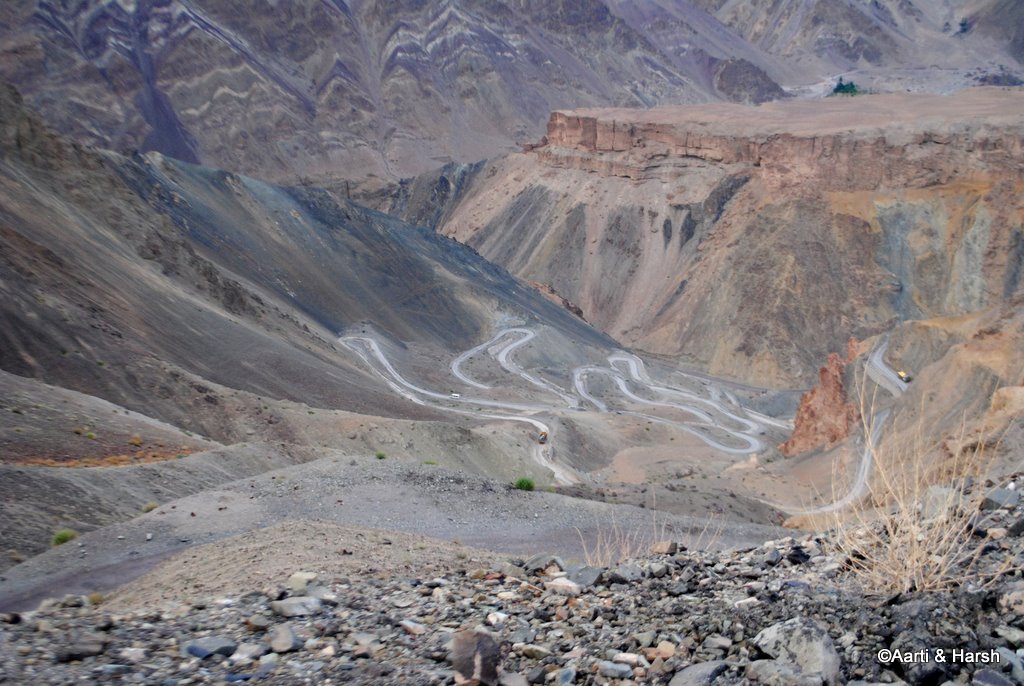
The moonscape at Lamayuru

Lamayuru
In an hour we had reached the main road and thought of giving the new road till Lamayuru a try. However, two workers stopped us, saying that some blasting work was going on and the road was closed for the day.
We then went back to take the jalebi road, which indeed is horrible. Some 30 switchbacks and much frustration later, we reached Lamayuru around 7:45 pm and went straight to Hotel Moonland, which had been recommended by our hotel guy in Leh. We got a nice, clean room at a reasonable rate. This marked an end to a long day of sightseeing in Sham Valley and other remote areas along the Srinagar Leh highway.
- Journey Ahead – A Road Trip on the Lesser Explored Batalik Route
Sham Valley Sightseeing
Our day in Sham Valley was really a highlight of our overall trip. We just drove through the valley and were so charmed with it that we decided to return and spend an entire day in Hemis Shukpachan Village. For our next trip, we will keep that as our base and explore the valley even further.

Sham Valley Sightseeing – Conclusion
I hope the travelogue, pictures, and information above on sightseeing in Sham Valley were of help. Please click on the link above to continue reading the next part of the travelogue. If you have any questions or need any other details, please feel free to ask in the comments section below, or at our Community Forum, and I will be glad to answer.